Sunday, May 22, 2005

Rainbow Wilderness

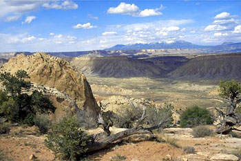
Greetings from the Upper Paria River, a 30-plus year old Wilderness Study Area (WSA) in a nine year old national monument. It’s day 37 on the Hayduke Trail. The scenery here is stunning; the Navajo and Kagenta sandstone forming deep red walls to offset the green vegetation, the blue of the desert sky, the white of the clouds and the latte color of the very silty river. The banks have been lined with flowers of every color: purple milk vetch; white, yellow, and pink of the desert evening primrose; the white and beige flowering spines of the Spanish bayonet; then there’s the tiny flowers, some of which resemble little daisies, others with their multiple yellow cups; the fiery red penstemon; the claret cup of the prickly pear cactus. Still others resemble freshly exploded fireworks, a ball of tiny white flowers only an inch or so across.

When we entered the canyon, down about 10 miles from where we are now, there were even more colors to keep the eyes overwhelmed. The chinle day layers were exposed beneath the sandstone, leaving layer upon layer of wildly colored strata visible. In some areas, more than 30 distinct layers of so many colors were angled up towards the massive monocline called the cockscomb. Brown, yellow, purple, gray, beige and tan, and an array that only a cosmetic salesgirl could begin to name.

The weather has finally turned nice, after over two weeks of cold, rainy days. We’re enjoying the sun and temperatures in the 80s. Good thing too. The water is cold and there are many crossings. Last night, I noted that it was fully 30 degrees warmer than at the same time three nights ago. I finally don’t have to layer up to be comfortable in my 45 degree down sleeping bag. My tent is for rain rather than warmth.

Here comes another rant…ATVs! For some reason, this monument allows unrestricted ATV access in a WSA. Today, we saw almost 30 of them, many of which apparently couldn’t be troubled to stay in the river bed or on trails. These people selfishly bully us into allowing them virtually everywhere, ridiculously citing “traditional” use – as if they rode these destructive, noisy machines even 20 years ago. The real traditional use seems to me to be walking and hunting and gathering, not tearing through the living crypt biotic soils while trying to “see” an entire river corridor in a day.

Even the use of horses is barely 100 years old in this desolate part of the American West. I’m sure these machines are fun, but do they really belong in a place special enough to receive protective designations by both republican and democrat administrations? I wonder what ol’ Hayduke would have to say about it….

Day 39
Round Valley Draw, Hackberry Canyon, the Paria River, Sheep Creek, and finally, Willis Creek; section eight’s wondrous drainages. Slot canyons, clear springs, wildly colored rock, fascinating ancient pictographs (those that are painted on rock) and petroglyphs (those that are etched or pecked into rock). Some are the most amazing I’ve ever seen, even cowboy / pioneer signatures dating back to the 1800’s when this land was still being settled by white folks, much of the region still unexplored.

We’ve all enjoyed this now completed section immensely, despite sunburn, chilly nights, snake encounters, morons on ATVs, quicksand and slippery wash bottoms. I even had my own quicksand “adventure” while exploring alone in a side canyon off the Paria River. I fell up to my thighs in a trap, tossing me forward as my body continued in the direction my feet could no longer lead me to. My arms went out instinctively to break my fall, but both sank into the goop nearly to my shoulders. Fortunately, a quick roll to the edge of the stream got me out, leaving me covered head to toe in sand, shaking with both adrenaline and fear.

Day 41
We’re now camped just outside the boundary of Bryce Canyon National Park, the fourth of six parks along the Hayduke Trail. The colorful cliffs have been drawing closer for a couple of days, the runoff from the snow covered Paunsaugant Plateau clearly showing its origin in the pink cliffs. Willis Creek led us all the way to Bryce’s Under-the-Rim Trail, which conveniently skirts the park boundary, allowing us to simply pop out of the park for free, permit less camping.

Bryce seems a little different than most of the journey so far. We’ve climbed to over 8000ft through aspens and ponderosas. Some of the shaded parts of the trail still have snow across it, and there has yet to be any maintenance on the trail this year. We are constantly having to work around fallen trees and slide-out areas. But that keeps a huge majority of folks off the trail. We’ve yet to see anyone else out here and only a couple of footprints.

We’ll now make a dash for the border of Arizona, where we’ll hop on the Arizona Trail, which will lead us to the just-opened North Rim of the mighty Grand Canyon, a mere 11 days, and more than 110 miles away!

Keep it wild!
From a happy and thinner Mike Coronella

Journey to Middle Earth

As the Grateful Dead so aptly put it, "What a long strange trip it's been." This adventure keeps taking unexpected twists, and there's a long way to go yet.

Coyote Gulch was awesome, with its waterfalls, fluted watercourse, arches, bridges, wild flowers, springs, and high red rock walls. Unfortunately, the weather was so great: rain and cold. Instead of sticking around to see if the sky would clear so we could go explore some slot canyons, Ray and I decided to head out. We ran into a few folks, including one fellow, who, to my surprise, rightly guessed we were on the Hayduke Trail. That was a first for sure.

We dug up the cache bucket and water that I stashed for section seven over the Kaiparowits Plateau, a section I had previously decided to sacrifice to allow for more time to enjoy the rest of the adventure. We quickly caught a ride to Escalante with three Californians who had also heard of the Hayduke Trail. They dropped us at the Escalante Outfitters, a wilderness-friendly business run by Steve Roberts and his son, Scott. There we chowed down a tasty pizza, crashed in their campground, and caught a warm shower after an icy night.

The next morning, we “cruised” Escalante, eating breakfast (not Clif Bars) and buying some books for the trail – I got only one by Ellen Meloy, and Ray bought two books about someone who has greatly influenced my world: Everett Ruess. I found it strange that the town of Escalante had so many references to Everett, as some town folks are most likely responsible for his disappearance so many years ago.

We next went to the Grand Staircase National Monument visitor center to see if we could learn about any good ways to kill a couple of days before meeting my brother at Bryce. Another visitor seemed amazed to learn that we were not only hiking the Hayduke Trail, but that I was a co-founder.

We decided to head to Bryce to poke around. It took us about three hours to hitch a ride, watching countless empty pick ups, SUV’s and RV’s go by until finally someone picked us up and delivered us to the park. The very first people we saw threw my head into a spin: it was two experienced hikers who bailed from the Hayduke Trail after finding 12 miles a day too much. (I tried to warn them…!)

Ben and Allison decided to restart at section eight, the section my brother was meeting us for. They’d been having nothing but bad luck: they spent two days in the rain waiting to drop in the narrows of Round Valley Draw before giving up and heading to Bryce for some hiking.

We decided to join forces – instead of just having my brother join me for this section, we’re now traveling in a pack of five: me, Ray, Ben and Allison, and my brother Chuck.

Before my brother met up with us, we stopped in the Bryce Visitor Center to inquire about trail conditions. Not only are the shuttles not yet running, which Chuck was planning on riding to get back to his rental car, we were told that Rainbow Point was snowed in and the Under-the-Rim Trail, which we had planned on traveling, was also buried under snow. We decided to check for ourselves. Turns out there is snow at Rainbow Point, but the Under-the-Rim Trail was virtually clear. Game on!

We shuttled out to Round Valley Draw just in time to get hammered by an icy rainstorm, which was followed by a cold frosty night. Fortunately, the weather seemed to break, and into the narrows we went. They were even better than I remembered, with sections where the sky was completely obliterated by the 250ft high canyon walls. In places you could touch both walls at once. The surprise: despite all the nasty weather, there was water only at the very beginning of the slot.

We spent the next day and a half in the wondrous Hackberry Canyon, first with Zionesque white cliffs and flat, dry sandy bottom, then as more and more seeps and springs sprung from the bottom of the Navajo Sandstone in a clear running channel surrounded by cottonwood trees and willow. Ray and I even got in a great side hike starting at 5:15am, climbing out of the canyon on the old “upper trail” and to the top of a huge sandstone tower we believe is called the Sandstone Donkey. What a view!

After visiting with two awesome mule packers, Mike and Allison, who were spending their retirement traveling the wild areas of the southwest, we came upon what appeared to be a juvenile bald eagle carcass. It was apparently the victim of poisoning (local ranchers don’t like predators and often set out poisoned meat to kill them, despite being illegal). A mile and a half of stunning narrows, complete with fish and quicksand (one trap caught Chuck, taking two of us to pull him out), brought us to the cockscomb.

We’re now camping at the confluence of Hackberry Canyon and Cottonwood Wash, and hopefully, I’ll be handing this update off tomorrow to a passing motorist on the Cottonwood Rd for delivery to Mountainzone.com.

Keep it Wild!
Mike Coronella and the rest of the Hayduke Gang

Tuesday, May 10, 2005

Thrashing Down the Escalante

As I mentioned earlier, it looks like I have a partner for the duration of this adventure; Ray Klukoska, a well-traveled fellow originally from Ohio. His summer’s Denali trip got cancelled, and he was looking an adventure, and adventures we’ve had! He managed to get things together, including putting out a couple of caches, before getting dropped off in Middle Moody Canyon.

We got to the Escalante River the first day Ray joined me – it was running pretty good. We decided to head to East Moody Canyon, a little over a mile down river, to get a feel for the water and our little trail boats. After figuring out how to get both body and backpack into these tiny vessels (which are rated for substantially less weight than we had in them), we floated down – and it was a hoot!

As soon as we got to East Moody, we were treated to an incredible thunderstorm, which we watched from the shelter of a massive amphitheater in the red rock wall. Waterfalls started coming off the 100-foot walls everywhere, some carrying huge amounts of debris. East Moody Creek quickly turned to a raging muddy torrent; we wondered what that would do to the river. In the morning we found out: the volume had easily doubled.

Ray’s boat was the first to sustain damage – a huge tear in the floor left him with just the main tube for flotation, but we made it to Scorpion Gulch without any more mishaps. Once again, a massive thunderstorm kicked in as soon as we got off the river. The next day, my 26th day out, showed a calmer river with the lower flow exposing rocks in the watercourse. We even had to portage around places that would have surely flipped our boats. Then Ray blew out the main tube in his boat, which we managed to repair by cutting a section off the popped floor. Then it was my turn – my floor blew out on a hidden rock. Next, my mini kayak-type paddle snapped in half, leaving me with a tiny little oar for maneuvering. Still, we made it to Fool’s Canyon, some 12 miles.

From Fool’s Canyon to Coyote Gulch is another eight miles. We figured it would be just a few hours. That was, of course, until Ray’s boat blew out completely, sending a spray of water up like a whale. We managed to get Ray and his pack to the riverbank, but his boat was lost. With one boat between us, we decided to let the packs ride, while Ray walked the river and lined / swam the boat down and I scrambled in and out of the water, keeping pace. At one point, hiking through deep grass, a surprised garter snake slithered right over my foot and I am NOT a fan of snakes.

A couple of hours later, a side canyon opened into view on river left, revealing a massive arch in the towering red wall. Stephen’s Arch; Coyote Gulch was only another long meander away. Our river adventure was nearing its end. The last half hour, though, was spent trudging in the river bed, which, at times, had been backed up by Lake Foul (Powell): deep gravelling quicksand that inundates the sandals, making for the most painful walking either of us had experienced. I finished barefoot.

Now at the mouth of Coyote Gulch, we were surprised to see two more boats coming down the river. Two men and a dog were nearing the end of their own adventure; they, however, had the proper boats (duckies), the proper gear (dry bags), and were headed down to the lake where a motorboat was waiting. They were amazed that we were able to make the trip with such bizarre little boats. They (thank you!) took the tattered remains of my boat out with them, saving me from carrying a few extra pounds for the next few days.

Now, a couple of easy days in Coyote Gulch…

Keep it wild,
Mike

Friday, May 06, 2005

Bursting Through Desert Spring

Editor's Note: This latest dispatch is Mike's fifth letter sent from the trail, but it only just arrived (the previous post is Mike's sixth letter).

Hey Mountainzoners!

It's now the 20th day of my travels on the Hayduke Trail. I'm camped in Capital Reef National Park, 12 miles into section six, having traveled the length of the lower Muley Twist today. The day started with rain, but an early morning rainbow brought hope. Indeed, I only dealt with a brief shower after that.

Today's cool sights were the walls of lower Muley Twist canyon and flowers. This spring the desert is just exploding with color: pink and white primrose, orange globe-mallow, red penstemon, red and purple paintbrush, purple and red cactus, white and black Spanish bayonet, and various others that I haven’t yet learned to identify. I was also able to enjoy listening to hummingbirds buzzing around and the beautiful descending scales of the canyon wren; it other words, it was a good day!

Day 21
It’s raining. I had an easy hike today, following game trails and an old wagon road down Hall’s Creek. There sure has been plenty of water so far on this desert trek. I’ve found surface water in virtually every drainage I’ve been in. Definitely not the norm out here, but certainly a good thing, as most springs and aquifers have been depleted by what many call the worst drought in 1,000 years. It almost makes me wish I was on the river, running Cataract Canyon or Desolation or Westwater.

I’ll get a bit of a river fix in a few days: my cache in Middle Moody Canyon contains a few unconventional items, like a Sevylor Trail boat and an old lifejacket for the Escalante River. Rumor has it that I might pick up a partner for the trail at the cache as well.

I ran into a friend, Turnin’ Pete, when I was back in Moab. He was in town for a post-ski season mountain bike trip. One of his buddies just found out that his Denali expedition was cancelled and was looking for an adventure. I set him up with what supplies I could – leftover gear from sponsors meant for Mitch. That gave him ten days to get his food together, place caches at a couple of locations and get added on to my permits. I got word yesterday that he plans to still meet me…

hiking hayduke trail
Looking out from the Burr Trail over the Waterpocket Fold,
Capital Reef National Park


Day 23
I’ve arrived at my cache in Middle Moody Canyon – all is intact. I actually got here a day early, having come up the Red Slide, a huge, ancient mud slide that came out of the Circle Cliffs into the Lower Waterpocket Fold in Capital Reef. Hitting the pass after a 2,220 ft climb brought me into wind and rain showers – no place to camp, so I trudged on. Too bad too – the view from the pass is as good as it gets, with the snow-capped peaks of three mountain ranges visible to the east (Henrys, La Sals, Abajos), poking over countless ridges and plateaus of every imaginable color – the red and white sandstones, the grays, yellows, purples and browns of the clay layers, and green – the desert is alive and growing this year!

All topped by the blue sky and white clouds. And then there’s the view to the west – the Kaiparowits Plateau (with snow) looming over the Red Rock Canyons of the Escalante River system, backed by the still snow-covered Table Cliff Plateau.

I’m sending this post with the fellows who dropped off a partner. More on that later!

Keep it wild!

Mike Coronella

Sunday, May 01, 2005

No More Wilderness

Editor's Note: This latest dispatch was sent by letter from the trail...

Hey Mountainzoners!

Back on the trail! And I am not alone for this section – my dog, Aldo, is along for some mountain climbing.

Yesterday we picked up the cache I stashed less than a month ago, all was intact. First one, hope that’s the way they all are! A long time ski buddy, Turnin’ Pete, joined us for the hike to Butler Wash – about mile five for the section. Along with his mountain bike (the Hayduke Trail follows roads to that point), Turnin’ Pete brought some steaks, hot dogs, and beer – I wasn’t the only one with a load. He rode out under a clear sky with a nearly full moon to light the way, leaving the dog and I to go on.

Hiking into the Henry Mountains is a walk through many geologic and vegetative layers. Where we’re resting now we’ve just hit the aspens and the snow-line. An intensely colored sunrise over a massive landscape – from the San Rafael swell to the La Sol Mountains to Sunset Pass and Elk Ridge – has given way to views limited by trees and a solid grey sky.

I’ve just found myself watching a “show” I’ve never seen before. The dog is napping while I’m sitting against my pack writing, listening to the sound of Crescent Creek bringing down the melting snow. A movement in the corner of my eye caught my attention: out walks a big, wild male turkey. I sat still, he kept doing whatever he was planning, lies down about 15 feet away, and just chills. Even when I moved to get my camera, it only grew alarmed when I walked right up to it to take a portrait.

I decided not to be a wimp and moved camp three and a half more miles, to about 9,400ft, almost 4,000ft higher than my previous camp. Finally, a reason for the snowshoes: shady and north aspens are still buried under several feet of snow. By the time I got to the new camp, I was soaking wet from the knees down – which is cold at that altitude.

I built a fire to dry my shoes, socks, and pants, and to melt some snow for water. Needless to say, no one else was up there, and I don’t expect to see anyone until I’m down lower towards Capital Reef National Park. The sunset brought the reward with the sun poking below the cloud layer, casting a shadow of the mountains on the red rock desert below. It was worth standing out in the icy wind for, too bad I still couldn’t make out the moon, which was full tonight.

I took off at sun-up this morning, hoping to take advantage of the frozen snowpack. Seems like crampons and an ice-ax would have been more helpful, at least until the sun softened the snow. And there was plenty enough snow for skiing. There must have been some remarkable corn conditions today.

The view from the Henry Mountains is nothing short of surreal – snow-covered, high alpine, yet canyons, plateaus and ridges are evident everywhere. It had me thinking about a comment left on a trail register I saw in Beef Basin on section three. It said, “No more wilderness.” I found this bizarre, as no matter where you look from the top, there is no wilderness. None. Over by the La Sal Mountains? Nope. Over by Elk Ridge and the Abajos? Nope. Lake Powell? Yeah right, the biggest piece of desert destruction imaginable. Capital Reef? No. Escalante Canyons? No! Fish Lake or Boulder Mountains? None there either. San Rafael Swell or the incomparable Dirty Devil River Corrider? No. All this land is still getting trampled and degraded by irresponsible and selfish people, cows, industries, and politicians. An Australian fellow I met last week put it best – “It’s the most beautiful area on earth.” Why can’t more people accept that and do their part to see it remains a planetary highlight? (If folks want to learn how to help, contact the Southern Utah Wilderness Alliance in Salt Lake City at www.suwa.org).

I’m packaging this letter up to hand to whomever will mail it. The next post could be a while, as I am going deep into the Escalante River, which just killed two canyoneers last week. I’ll be careful.

Keep it wild,

Mike Coronella