
Trekking Nepal's Kangchenjunga region...
March 7, 2006
|
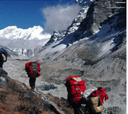
| Porters lead the way... Photo Courtesy of P. Media |
As we neared Pangpema, the dramatic Chang Himal/Wedge Peak rose straight up from the Kangchenjunga Glacier to 6,750 meters. While smaller in comparison to other peaks, its fluted face is spectacular. No sooner had Chang Himal been passed, than Pangpema greeted us with a view of the north face of mighty Kangchenjunga. Even when 8 kilometers away, its sheer size fooled us into thinking it was a mere two-three kilometers away. At 5,200 meters the air is very thin and you only have 52 percent of the oxygen that would normally available at sea level. I struggled to shake a lethargic mood, preferring to rest and read and suck in my full 52 percent of oxygen. Pangpema consisted of a couple of basic stone huts and tents dotted from another trekking group and a mountaineering group. After a stunning evening with a full moon and a cold night in the tents, we progressed back down valley with the sun shining strongly. My legs appreciated the gentle descent and the thicker air was my appreciated by my lungs.
On the return to Kamberchen, the punters and our fantastic crew spent a spare afternoon taking part in the inaugural “Kamberchen Games.” Led by an enthusiastic Australian, staff and punters were randomly divided into teams to participate in activities such as egg and spoon and three-legged races and the “Dungcus.” The “Dungcus” is discus modified to suit the local conditions— dried yak dung being the local resource. The Kamberchen games provided hilarious entertainment for the local yak herder spectators; which was fortunate as dung being thrown was exploding on and through their front doors. The closing ceremony took the form of the limbo with the flexible Nepalese leaving the westerners on their knees.
The air seemed to warm as we strolled down to Ghunsa where we met a group of Kiwis being led by well-known mountaineer Colin Monteath. We then tackled the two-day journey across a series of high passes to the Yalung Valley— the southern approach to Kangchenjunga. Four of the five passes topped 4,000 meters.
The recent fine weather left the passes almost snow free; with good acclimatization the walk wasn't too arduous and the views were superb. The horizon included the formidable Jannu, Makalu , the world's fifth highest peak at 8,463 meters and, finally through to a small bump just in sight, the summit of the big one, Mount Everest.
The gentle slopes the Yalung Valley ensured a straightforward wander to the camp at Ramche, just short of the southern Kangchenjunga base camp. The temperatures by now were rather chilly with overnight lows dropping to 20 below. A fire lit by the porters offered some warmth, but I could only shiver as one hardy porter continued to walk barefoot. All that lay between us and the border of Sikkim was the Yalung glacier and the 7,000-meter peaks of the Kabru range. It was from beside the glacier that we headed up to Oktang.
At 4,800 meters, Oktang is represented by a chorten and prayer flags. From here, a scree bash was required to reach an area where expeditions base themselves for the southern ascent of Kangchenjunga. Although lower than the northern base camp, this spot was no less spectacular, with big peaks surrounding us and Jannu's base camp just below.
|
|
Such vistas did not urge any rush to return to the hot lowlands. The long return journey was punctuated with backward glances, revealing last glimpses of the mighty peaks. However, the final leg of the journey provided again the cultural experiences and views of carved terraced hillsides lush with rice and other crops.
Smiling school children crammed window frames of their dark classrooms crying “Namaste,” amused by the novelty of westerners walking through their rarely trekked valley. The red flags flying from school flagpoles though reminded us that the Maoists had stamped their authority on the region, many people living with an element of fear they were not used to.
A drama-less flight took us from the beautiful mountains to the hot and quiet capital of Kathmandu where a public holiday provided us with a chance to re-acclimatize to chaotic city life. Cries to sell hash, tiger balm and chess sets and honking horns would be back to full swing the next day.
Notes
Trekking in the Kangchenjunga region requires a permit and a guide at all. While teahouse trekking is only just possible, the numbers of teahouses are few and far between. A guide will fulfil the government requirements and be able to track down spots for you to stay and eat at. Several tour companies operate trips, but the only other signs of westerners will be the occasional mountaineering group. Visiting both base camps normally entails a 25-day trek. To get to the region most people fly from Kathmandu to Biratnagar before boarding another flight the following day to Suketar.
Story by P. Media