
Hiking Back Through History
May 3, 2006
|
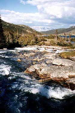
| The View From Deep Camp Photo by Paul Nickodem |
Alaska's most famous trail is also its most historic. Spanning just 33 miles from its start in Dyea to Bennett, British Columbia, it offers a century of lessons along its craggy way.
One hundred years ago thousands of gold-crazed prospectors struggled over this former Tlingit tribe trade route. With them, they brought a ton of supplies as required by the Canadian Mounted Police. Signs of their struggle remain: broken teapots, wagon wheels, shoes, horse bones, graves, and the unfortunate, broken dreams of men who sought a better life.
We flew out of Juneau on tiny Skagway air, which is just a Piper Archer four seat aircraft. I was the co-pilot as we flew up the fjords and channels toward Skagway (population 1,500). My pilot was a 21-year-old girl from South Dakota and when she told me her age, I felt like wrenching the controls from her. The landing in Skagway would have made even the most gnarly world traveler cringe—major pucker factor as we skimmed a ridge and then stood the plane on its right wing as we banked into the deep corner of the mountains that Skagway is built into.
Galit, my good friend from New York, and I checked into the cute little Skagway Home Hostel. Then we went out for pizza and a beer, and some great conversation with a drunken Alaskan Ferry Captain.
|
|
In the morning, the eccentric owner of the only hostel in town dropped us at the trailhead and we immediately hosed down with bug spray as thousands of Alaska's finest were soaking us dry with their hypodermic needles. The beginning of the trail was very surprisingly Appalachian Trail-like, very deep and woodsy, and also boggy at times. Coming over the first big hill, the trail became a quagmire of boot grabbin' mud. The trail was not the pushover that I thought it might be since so many people do it every year; it was a rough trail, with lots of rocks, especially on the Canadian side. We took a break at Canyon City, which actually used to be a city of 5,000, the only sign of which now was a rusty boiler, which marked the spot and a warming cabin for hikers.
Along the trail there are pictures mounted on big iron frames, which show what the trail looked like a hundred years ago. It's just weird coming over a huge rock fall and snowfield and finding a picture and story to read. We made it to Sheep Camp the first night, which is about 11 miles in. That night we got a talk from the Rangers about the usual bear danger, avalanche danger, and some history on the trail.