|
|
| |||||||||||||||||||||||||
Hiking Canyonlands' Joint Trail
It's a hot autumn afternoon on U.S. 191 heading south out of Moab. We turn right onto 211 West and enter Canyonlands National Park. We pay the $10 entry fee and head into the Needles district, one of four districts in the park. The best time to hike in these parts is from March to May and late August to early November, as the summers are sweltering and the winters are cold. We've picked today to hike because of the full harvest moon that we hope will illuminate our way back from the Joint Trail.
We park at Squaw Flat Campground, which has trailhead parking, potable water, toilets and camping sites. The sites are usually in use, however, as they are first-come, first-served. There are also eight designated backpacking sites that require a $10 permit. We decide to leave the park after our hike and camp in the nearby rock climbing mecca of Indian Creek, which has free, dispersed camping.
With our camelbag bulging and several Nalgene water bottles resting against snacks and extra fleece in the pack, we begin our 15-mile round trip at 4pm. The trails are marked well with cairns (small rock piles) and signs at intersections. Out of the parking lot, we take Big Spring trail for 0.5 miles, which connects us to the Squaw Flat Trail. There are multiple routes to the Joint Trail, but this is the most direct. We hike over a mixture of slickrock, loose rock and sandy washes. We travel 3.5 miles, then join the Chesler Park Trail. Here and there we see black Cryptobiotic crust, the desert's topsoil, which resembles a lunar landscape. Upon entrance, visitors are told that this crust is really a community of organisms such as lichen, algae, and fungi and that it takes hundreds of years for the fragile desert vegetation to grow back if it's stepped on.
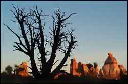
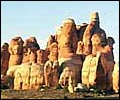
We pass under rock walls, which provide short shady respites from the sun, and notice the desert varnish, or dark stains on the surface of walls caused by water drawing out iron and manganese from the rocks. Little lizards scatter everywhere. Juniper trees reach out their dry branches. Then we see it, like the biggest and best-organized defensive line, the Needles formation stands shoulder-to-shoulder, both dwarfing and astonishing us. They look as though they bubbled out of the ground. Layers of sandstone, limestone and paradox make up the Needles, but it's the easily eroded paradox layer which causes the whole area to tilt into the Colorado River.
A sign tells us we have 4.2 miles to go. We scramble up a moderately exposed and steep rocky section and emerge into the scenic expanse of Chesler Park. The trail takes us briefly on a sandy four-wheel drive road surrounded by desert grasses and shrubs. More compelling, however, are the spires around us which, like clouds, turn into recognizable shapes as we pass by. The sun has yet to set, perfect timing to descend into the dark fissure that is the Joint Trail.
The Joint Trail is simply a huge rock that was split from the same weakness of the paradox layer that formed the Needles. We climb down into the deep, narrow fracture and enter another world where sound is oddly dampened and the remains of the sunlight struggle in. We move quickly between the cold rocks, not even an arm's length of space between each towering wall, and feel the same excitement a child does when entering a dark basement. Short of a mile we reach a garden of cairns, zealously marking the end of the Joint Trail.
We double back, climbing out onto the rocks in time to catch the colors of the sunset over the Maze district. It's time for food, fleece and water. Twilight comes quick in Chesler Park and the sandy road makes for easy walking. The stars come out and so do our headlamps. The numerous cairns are easy to find and we begin to see the fluorescent glow of the harvest moon from behind the rock formations.
For more of a challenge, we could hike two extra miles to Druid Arch or hike the larger Big Spring loop through intricate canyons connected by ancient ladders, but we decide to take the same way back. After we leave Chesler Park, the moon lights up the desert and we turn the headlamps off to hike silently under the muted stars. Our legs and feet feel the last 13 miles. We hit the two-mile mark and keep a swift pace, arriving back at the parking lot at 10pm. We pack up quietly and drive 20 minutes to Indian Creek. The next morning we wake to the same desert weather as the day before and watch the moon set and the sunrise simultaneously.
— Krista Crabtree, MountainZone.com Correspondent
SEE ALSO: Hiking in Thailand | More Hiking
|
|
||||||||||||||||||||||||

| |||||||||||||||||||||||||